Seeing the wood for the trees: Why natural feature matching navigation works so well for mobile robots
For automated guided vehicles and autonomous mobile robots to operate, they need to know where they are, where they need to go, and how to get there.
While simple “line following” technologies have their place, they have high installation overheads and, because they require changes to permanent infrastructure, do not lend themselves to adaptation to new requirements.
Natural feature matching navigation is based on using permanent features along the route of the AMR, is easier to install and more flexible for future needs. But how does it work and why does it work so well?
The type of navigation technology used in an AMR has one of the biggest impacts on its performance. In the main, “natural” or “free” navigation uses one of two technologies: scan matching (sometimes called SLAM – simultaneous localization and mapping) or feature matching.
Both technologies need to be able to “see” to match with features in the environment. The difference between the two is the references the robot uses to calculate where it is.
Scan matching navigation uses lasers to measure the area around the robot and compare (match) this with a pre-prepared grid-based reference map. It is like comparing the pixels between images to see if they are the same.
The AMR calculates where it is based on the matched points it finds, while using motion sensors to determine its change in position (odometry) as it moves relative to the identified point.
The problem with scan matching navigation is the density of the grid map and the number of points it needs to recognize for accurate positioning. It uses SLAM to both create the map and then to regularly update it.
Imagine a forest with trees, leaves and animals. The robot would scan all of these to formulate its reference map. However, the next time the robot passes through, the animals and leaves will have moved, creating many map updates and making it difficult for the AMR to work out its position. Basically, it would have too many points to match.
While a forest is an extreme example of an environment, the principal remains the same. All environments may change slightly, and a scan matching AMR would need to be able to identify around 60 percent of the points around it for accurate and reliable localization.
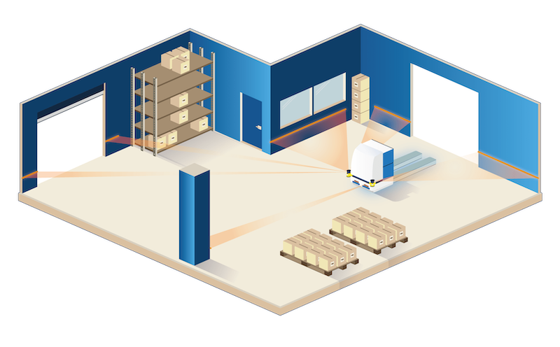
When using feature matching navigation technology, such as ANT from BlueBotics, scans from the robot’s lasers are compared with permanent features such as pillars or walls.
The size and angle of each object makes it easy for the robot to identify and, although the original map is created using SLAM technology while manually driving the robot through the site, the ANT integrator removes all dynamic objects to leave a simple map for the robot to follow.
In the forest example above, a feature matching AMR would only use fixed points: the tree trunks. Instead of a dense picture of all the elements in the forest, it is left with a basic line drawing of key infrastructure to follow.
By ignoring all the moving parts, it only needs to identify a small percentage (around 5 percent) of its environment to navigate accurately and effectively. It still uses odometry to calculate its position as it moves. So, even if features are blocked from view or cannot be matched for a short time, it can continue to move a few meters.
So why is feature matching navigation so accurate and safe?
As permanent features are used as references to calculate the robot’s position and the map is never updated, this guarantees high precision over time and the map is more robust and resilient against dynamic changes in the environment. With scan matching, the continual update of the map can mean measurement errors creep in and compound overtime, reducing accuracy.
Although feature matching navigation technology is designed to ignore dynamic objects, an ANT driven robot will not collide with unexpected obstacles in its path.
The lasers onboard the AMR continuously monitor the environment and, if an obstacle is detected, the robot can be programmed to either stop and wait for the obstacle to clear or to avoid the obstacle (obstacle avoidance) by adjusting its path to navigate around it.
Multiple AMRs
ANT technology can be applied to operate across integrated fleets of vehicles and work with varied types of AMR and automated guided vehicles (AGVs).
ANT server software coordinates fleets of robots across a site while the way the feature matching navigation technology works means it can be applied to virtually any type of robot or vehicle.
A scan matching AMR usually employs a dedicated laser scanner for navigation situated high up to enable it to “see” as much of the environment as possible.
However, by using feature matching technology, the robot only needs to identify a relatively small proportion of the environment, meaning low-level safety scanners can be utilized for navigation. It also means that the height of the robot is not an issue and that the technology can be applied to varied forms of AMRs and AGVs for them to work seamlessly together throughout a facility.
Moving outdoors
As industries increase levels of automation to add efficiency and consistency to processes, the use of AMRs is growing, and this includes outdoor applications. The movement of goods and materials between buildings and beyond presents additional challenges but is a growing and well proven application for these robots.
When moving outdoors, robots must be designed to handle varied and inclement weather conditions – and this includes the navigation. Outdoors, dynamic elements the robot needs to see past to enable localization include dust, rain or even snow.
Like the forest example, the use of feature matching navigation makes it easier for the AMR to identify the features it needs to reliably navigate outdoor territories. Its simple “line drawing” rather than dense picture means it can see past the visual noise created by the weather.
Successful applications
Can your robots see the wood for the trees? The choice of navigation is critical to the successful application of an AMR. For installations that are looking for added flexibility, natural feature matching technology offers a versatile, adaptable and robust solution in dynamic environment.
Its ease of installation, requiring no permanent changes to infrastructure, high accuracy, and versatility makes it a system of choice for any vehicle type.