Drones are bridging the gap in US inspection technology
Drones and non-destructive testing devices are shaping the future of bridge inspection and rehabilitation, by helping to improve project safety, reduce costs, and create more efficient and sustainable methods.
There are critical infrastructure needs across North America, especially when it comes to bridges. In the U.S., for example, over 54,000 U.S. bridges are structurally deficient, which is nearly 9% of all bridges across the country.
Not only that, but assessing the current state of bridge infrastructure requires an increasing amount of time and resources – and there are no shortage of safety concerns.
Thankfully, new technologies are here to help. Long before inspection and maintenance, drone data platforms such as 3DR Site Scan are being used at the very beginning of infrastructure projects to improve the way bridges are built in the first place.
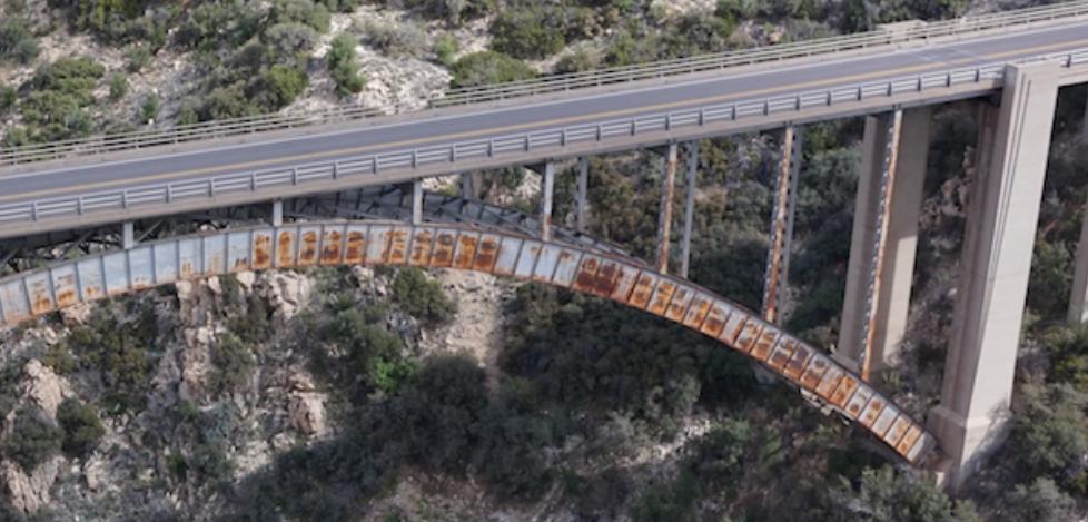
For example, drone data helped the Arizona Department of Transportation (DOT) capture up-to-date existing conditions of their ageing Pinto Creek bridge, and design a new bridge to replace it.
Creating 2D maps and 3D models with drones has also been used to better document important utilities – like rebar and post-tensioned cables – before pouring concrete. This type of detailed documentation at key milestones can make a big difference on large-scale concrete construction projects, helping identify and address issues that may otherwise have been missed.
Although surveying, planning, and quality control are common uses for drones in construction, they’re also increasingly being used post-build in the inspection process.
As an American Association of State Highway and Transportation Officials study found, 35 state DOTs are using drones for a variety of purposes, with 20 of them using drones daily and another 15 testing drones and determining how they can best put them to work.
Drones are capable of collecting far more detailed inspection data compared to snoopers and other more traditional inspection equipment.
Not only that, but drones can collect this data without interfering with traffic, which is a big cost-saver: the Michigan DOT found that shutting down a four-lane, two-way highway bridge in a metropolitan area costs approximately $14,600 during the 10-hour period it typically takes to do a bridge inspection.
AASHTO did another study in 2016, comparing the price and labour needed to perform bridge inspections manually compared with a drone-based workflow.
They found that not only did manual inspection require twice as many people, it also cost upwards of 18x more than using drones. That’s why, for DOTs, adopting drones is a no-brainer: they can perform inspections more frequently, cost-effectively, safely, and capture more information than ever before.
From gathering the initial data via still and infrared images, to being equipped with non-destructive testing devices for in-depth analysis, drones can be used for bridge inspection in a variety of ways.
They make it easy to collect high-definition images and visual data from traditionally hard-to-reach areas, such as the underside of bridges and along the beams and girders.
They also dramatically reduce cost and safety risks associated with traditional bridge inspection by eliminating the use of heavy machinery.
The 3DR Site Scan platform, for example, can capture high-resolution images from inspection flights, or target and outline an area to capture oblique imagery from four directions.
It also has the capabilities to re-fly previous flight patterns, so images can be gathered from the same area and compared at different time intervals to view deterioration and changes in infrastructure.
While most inspection drones are currently equipped with high-resolution RGB and thermal cameras, that’s just the beginning: innovative firms such as Giatec Scientific are equipping drones with their non-destructive testing equipment, such as the iCOR device.
The iCOR is used to detect corrosion in reinforced concrete structures, and map corrosion potential and rate. What makes the iCOR unique – and gives it the ability to be used in combination with drones – is that it can perform tests in seconds and without the need for a physical connection to the rebar.
Using the data gathered with drones, in combination with corrosion assessment from tools like iCOR, contractors and inspectors can get an all-around, in-depth look at the state of bridges and concrete infrastructure.
It also keeps workers out of harm’s way, amounts to considerable cost savings, and most importantly, it’s helping state DOTs, engineers, and contractors do a critical job: repairing and replacing ageing infrastructure across the USA.